 Quin the explorer heading down the hill leading to Bluebell in Conneaut, Ohio.
This past spring has been hard on the road. The erosion channel cut into the road bed is up to a couple feet deep in some places.
 Quin and I walked up the old road approach to the bridge. The wooden decking is long gone, and the grapevines are taking over. In the upper left hand corner of the photo (left) you can see where the bridge frame is propping up a large old sycamore – shown from below in this photo (below)

At the top of the bow of the Creek, the far bank is eroded by the faster-moving water, while on the side Quin and I were on, large deposits of alluvial material (in this case, sand) occur.

Around the bend, we found our old friend, Mr. Canadian Goose. He didn’t puff and preen at us today, though – he just took off!

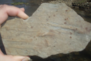
Weathered shale is deposited all along Conneaut Creek, as it forms the Creek bed. Deposits like this are prime placed to find fossils!

 I call these ‘lake bottom’ fossils – not sure the appropriate term – it’s like the bottom a some long-ago lake was frozen in time in the shale.
In this particular section of the Creek, several layered oxbow ‘lakes’ (more like ponds) have been created. During high water, these oxbow may still carry water, but for the most part they are stagnant ponds, that may even dry up during the summer.
Quin the environmentalist helps with litter pickup. We have gotten into the habit of carrying a bag for garbage when we walk down here. It was full by the time we got back home.

Deer track, in addition to other wildlife, are fun to find.

This time of year, the signs of spring are just beginning to emerge, but the skeletal trees along the Creek are beautiful in their own right. The water in the Creek was muddy today. Rain and snowmelt carry sediment via overland flow, creating the muddy condition. When the Creek is at base flow the water is crystal clear, and COLD. The groundwater that contributes the base flow of the Creek stays right around 56 degrees F year round.
Quin took a little rest in this tree by the Creek – 

but not for long. He was up and adventuring again, in short order! 


Views of the Creek looking downstream, the way we’d come (left) and upstream towards home (above). Our home is only about 1500 feet upstream of here, but lies approximately 60 feet above the flood plain.
 Quin the conqueror on a concretion weathered out of the shale at the edge of the water. We find small concretions, as well as quite a bit of flint, Ohio’s official gemstone.


Views of the Creek looking downstream, the way we’d come (left) and upstream towards home (above). Our home is only about 1500 feet upstream of here, but lies approximately 60 feet above the flood plain.
 Quin the conqueror on a concretion weathered out of the shale at the edge of the water. We find small concretions, as well as quite a bit of flint, Ohio’s official gemstone.
The road home. Quin and I really enjoy our walks together. We’ll begin expanding our wanderings, and I will try to remember the camera so we can document our adventures!


OK, the photo essay thing was a PITA. I hate Google's WYSIWYG editor ('cause what you ain't what you get). But at least the photos are up. Sorry the formatting is off - but the pics are there with the words!
ReplyDeleteWhat a fabulous walk y'all took. I love the tree Quin stopped to rest on. It looks like it has character.
ReplyDeleteHelen
http://straightfromhel.blogspot.com